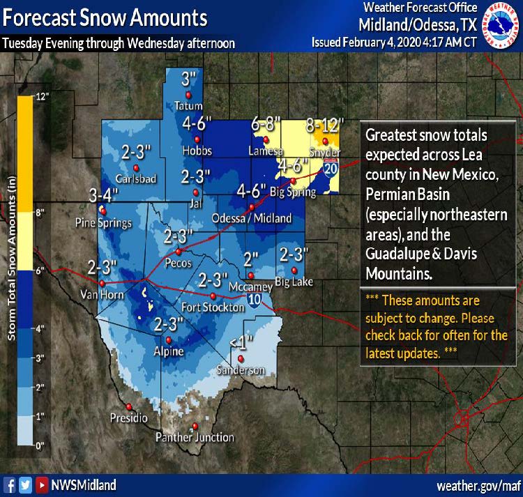
Strong potential for moderate snow storm, up to 8” Tuesday through Wednesday. NWS advises forecast is being updated each day but this appears a likely scenario for now. Public needs to prepare for icy roads, delayed travel and possible power outages. It is also possible the schools could cancel, but that decision will come from the individual ISD’s. “Failing to prepare is preparing to fail”.
Winter Weather Safety
Vehicle Preparedness & Safety
- Plan your travel and check the latest forecasts.
- If you encounter snow or sleet drive extremely cautiously, even 4-wheel drive vehicles will have difficulty on icy roads.
- Dressing for the Weather
- Wear loose-fitting, lightweight clothing in several layers.
- Outer garments should be tightly-woven and water-repellant.
- Wear a hat. Nearly half of your body heat loss is from the top of your head.
- Wear gloves or mittens (mittens snug at the wrist are better than gloves).
- Preparing Your Home
- Bring your pets inside.
- Have a flashlight and extra batteries available. Don’t use candles if the electricity goes out.
- Use a battery-powered NOAA Weather Radio and a portable radio to receive emergency information.
- Be sure to wrap any exposed pipes.